Changelog
Stay up to date on product updates and new features.
June 16, 2026
Google Calendar Integration
As we continue to build up on our AI capability, we are also adding new features. We are excited to announce that you can now connect your data from any Google Calendar!
You can do this in the Chat or Customise section.

May 1, 2026
Map legends
As we continue to build up on our AI capability, we are also adding new features. We are excited to announce that you can now add map legends to your map.
You can add Legend in the Chat or Customise section. We have also made it possible for you to make customisations including where you want to show your legend and how how much details to show.


March 1, 2026
New use case added!
This year we plan to add more interactive map types and use cases - starting with area maps. Previously we could only map boundaries with KML files now you can create area or boundary maps with our AI chat. See an example below - all you have to do is tell AI the country or region you want to highlight and the colour and style.

December 1, 2025
Our AI revamp is done!
We are super excited to announce that our AI revamp is done! We are now a true AI-first map builder. This means you can now create and customise your maps with text prompts.
Now, when you create a new map or edit an existing one, you will see these two tabs - 'Chat' and 'Customise'. The previous click-based menu is still available under the 'Customise' tab. Over time, the 'Chat' tab and ' Customise' tab will be integrated to allow an even more intuitive user experience.

August 27, 2025
Our AI-first revamp progress update
I know we have been quiet over the last few months. Behind the scene, we have been revamping our many parts of our mapping engine to be AI-based. This marks a major step forward our grand vision of allowing you to create any map, from any data, faster and easier.
Just like all the other Gen AI applications, we too have been running experiments with AI and see how we can best implement them. It's been a fun and challenging experience so far.
Some of the AI implementations we have already released include:
1. Auto-naming your map based on your data
2. Use AI to better understand your data format then use these insights to automatically set up your data configuration.
3. Auto generate a map theme based on your prompt. Creating a map theme has always been difficult and require days to create map themed
4. Allow your to highlight boundaries of cities and countries purely based on your prompt.
What we working on next:
1. Create a natural language based map creator - so we will be a true AI-first map generator
2. Imagine a virtual map expert advisor who would guide you all the way to create a customised map that you desire, in the matter of minutes.
May 19, 2025
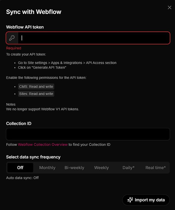
Real-time data update for Webflow
For all the Webflow users, we are excited to announce that you can now have your data updated in real-time! In response to Webflow's recent token upgrade, we have also upgraded to v2 token. Please note v1 token will not work anymore. To set up real-time data sync, simply go to your data configure/setup section and click on "real-time". That's it!
April 23, 2025
New feature: make heatmap
We are excited to announce that you can now add a heatmap layer to your map. You can upload your heatmap data under "Import data" - "Heatmap", and your heatmap will be created in seconds.


March 31, 2025
Our AI map style generator is here
We are excited to announce that in addition to our 6 standard map styles. We have just released our AI map style generator so you can design your own unique map style with just text prompts. You now can create any map style for anywhere in the world.


February 11, 2025
Our first AI release is here!
We are excited to announce that our AI revamp is here - No Code Map App is now AI-powered!
You can now customise your map with just simple text prompts. Please give it a try!
December 12, 2024
New pop-up style added
We are excited to announce that we have added a new pop-up window style. You can now show a smaller pop-up above your location marker.
To set it up, simply go to the "Pop-up box" section and you will now see two options:
1. Full - this is our original pop-up window style which shows a pop-up box on the bottom left corner of the map, and
2. Minimal - this is our new smaller pop-up window style which shows a smaller pop-up box above the location marker.


December 4, 2024
Layout change
Over the last month or so, we worked on a series of performance upgrades and design improvements. The biggest change is where we show our selection of templates.
We have removed our previous "Template" section. So now, when you click on "add a new map", you will see a new screen asking you to choose a template.

Inside each map editing view, you will find the list of templates under "Customise".

October 21, 2024
Team collaboration
We are super excited to announce that you can now collaborate with your team members!
You can now add people to your maps and edit together - all you need to do is add their emails under the "Collaborator" section.


October 4, 2024
Introducing video embed
We are super excited to announce that you can now embed videos to your locations!
As a part of this new release, we have also combined image, audio and video embed into a new media section.


September 24, 2024
New feature release
For those of you working with limited screen space, you can now set your default display to have your list view collapsed.
The default setting for all maps is set to show list view, so if you want to collapse your list view, simply switch it off.

September 23, 2024
Real-time data sync for Airtable
We are super excited to announce that all Airtable users can now set up real-time data sync!
You can set it up under the Data section. All you have to do is click on the Set up button then follow the instruction. It should only take a couple of minutes to set up.


Important update to Airtable users
Airtable has deprecated usage of API Keys since Feb 2024. New integrations shall use Personal Access Tokens going forward and it's 100% compatible with us.
You need to create a new Personal Access Token instead (above the "Developer Key" item in the menu) . The new token has a format of "patXXXXX" and is much longer than the old keys. When it asks you to set permission scopes, can you set the scope to:

July 29, 2024
New upgrades
For the last couple of months, we have been quietly doing a whole batch of miscellaneous upgrades, including:
1. Better data field detection
We have improved our automatic data column detection at the import stage, so data columns with website URLs will now automatically show in the call-to-action dropdown menu.
2. Excess white space in List View removed
We have optimized our list view UI so you won't see excessive white spaces anymore.
3. Map filters upgraded
We have just upgraded our map filters so with dates and some number based filters like prices and latitude, you will see a more advanced filter.

May 27, 2024
New upgrades
We have just released 2 new feature upgrades.
1. Airtable integration upgraded
We have just released the new upgrade to our Airtable integration - It enables automatic lookup to "Linked" columns in your tables so you don't just get IDs when you import those columns but you shall have proper labels from their linked tables.
2. Line break
We now recognise line breaks in your data. So data fields with multiple lines will now show as separate lines.

May 16, 2024
New feature release
We have just released 3 new features to our Customise section.
1. Ability to switch on/off cluster marker
You can find this at the bottom of the "Marker" section.

2. Ability to automatically request site visitor's current location
You can find this in the "Visitor current location" section.
So you now have 3 options:
-
Show nothing at all
-
Addd a button for visitors to click on to show their current location, and
-
add a button as well as show a popup message to automatically request visitor's current location.


3. Show terms of use
We add a new feature under "Customise" section to allow you to show a terms of use message. You can customise this message and add to the link to your terms of use.


April 30, 2024
Map loading optimisation
We have made some exciting improvements to the loading speed of our maps, especially for large maps!
The main thing we optimised is the way data are loaded:
-
Before: Load all 10,000 locations -> Load Google Map -> Show map to users
-
Now: Load Google Map -> Load 500 locations -> Show map to users (while loading remaining locations in the background)
This change helps to show your maps to your users ASAP, so your audience can start interacting with your map while the remaining locations are being loaded in the background. We expect this to be most impactful to big maps with >2K locations.
April 15, 2024
Zillow-like real estate template
We are excited to announce that we have just released a new premium Real Estate Template, designed based on the Zillow map.

April 3, 2024
Data sync optimisation
One of the biggest complaints we get is that once map has been created, if you add or remove data fields/columns, it won't work. For the last few weeks, we have been working on fixing this!
We are excited to announce that we have just released a new feature that allows you to re-configure the data fields for your map without needing to re-import your entire map from scratch and lose all your configurations.
This new feature cover the following use case scenarios:
1. You've added a new column in your data source (e.g., google sheets), and would like to include it in your map.
2. You'd like to change an existing column into a different type. Ex., you'd like to change a column "website url" to be a "call-to-action" field instead of a "website" field.
3. Remove an existing column from your map to keep things organised.
For scenario 1, it is of course automatic whenever you resync your data. For Scenario 2 and 3, you can reconfigure your data columns/data here under the newly add sub-section "Re-configure your data fields".

March 7, 2024
New feature release: Duplicate map
You can now duplicate your map with just a click of a button! On your dashboard, on the upper right corner of your map block, click on the menu button ("3 dots") and you will see the option to duplicate your map!

February 26, 2024
New feature release
We have released 2 new feature releases over the weekend:
1. Call to action - new trigger setting
2. Map theme - ability to create your own custom base map
Call to action enhancement
Under "Calls-to-action", when you add a call to action to your map, you now have the option to set a call to action without having to create a button. You can set it so the action can be triggered by clicking anywhere in the list view. Given how it works, this setting would only work for the first CTA if you have multiple CTA. For the other CTA's you would need to assign CTA buttons

Map theme enhancement
Under Map theme, you can now create your own custom base map.

February 19, 2024
New feature release: Share button
You can now add a Share button to your pop up. The switch can be found under "3. Customise - Pop up".


February 5, 2024
Subscription price increases
Almost exactly two years ago, we released the very first version of No Code Map App. Since then, we have been working with our early adopters and added features proven to be mission critical for many businesses.
We decided it is time we increase our subscription prices. Starting today, Pro plan will increase from $15 to $24 per month, Business plan will increase from $39 to $49 per month and Company tier will increase from $99 to $149. We have a long list of exciting new features and upgrades planned for 2024. So please stay tuned!
January 22, 2024
Slack community channel now live!
As our customer base continue to grow, we have decided to set up a Slack channel for all of our paying customers where they can ask questions and get product updates. We believe this would allow us to provide better customer service and tech support for our customers.
December 18, 2023
Advanced analytics
With holidays coming up, we are going to make one last major release. We have been asked to show more data on map engagement, so here we are - the first phase of advanced analytics. Now you can see a number of different metrics on your dashboard under each map, including: total number of map views, number of pop-up opened, CTA clicks, map filters used, and map searches.

November 6, 2023
Multi-language translation
Many of our users operate in non-English speaking regions, so we often get asked if they could translate into other languages. We are super excited to announce that our multi-language translation feature is now available!
This means you can show your map in 3 languages and have a switch on the map. Under 3. Customise, you can add up to 3 languages.


September 25, 2023
Auto data sync Phase 2
We have a couple of exciting new releases this week.
1. Automatic data sync is now available for Google Sheets
Phase 2 of our Auto-data sync feature has been released, which means it is now also available for all Google Sheets database integration and all Company tier subscribers can also set the update frequency to daily and even hourly!
2. Set radius for your search bar
Under 3. Customise -> Search bar, You can now set radius for your search bar so even more control on how your research results are shown.
September 12, 2023
Automatic real-time data sync
We are super excited to announce that automatic data sync is here! This is one of our most highly anticipated and requested features.
We will be releasing this feature in phases:
-
Phase 1 - You can set auto update frequency to Weekly, Bi-weekly or Every 4 weeks. This is now live on our platform and works for all Airtable and Webflow CMS users. Google Sheets will be available soon too.
-
Phase 2 - You will be able to set update frequency to Daily or Hourly. This enhanced update frequency will be a part of our new Company tier pricing plan.
How it works
In 2. Data section, you will now see a step 2. Simply select the frequency you prefer, and that is it, your map will be automatically updated.

August 28, 2023
Choose which data field to map
To map your locations, we currently require two data fields: a Name field and an Address field. To decide which fields to use, we simply scan through your data fields and auto-detect which fields to use based on your data field names (or column headings).
This means you must have at least one of your data columns with the word "Name" in it and one with the word "Address" or "Location" in it. This can be inconvenient at times. So, to make it more flexible, we have now added the ability for you to choose which data field to use as the Name and Address.

July 17, 2023
Customise CTA link opening behavior
We are excited to announce that you can now customise your CTA link opening behaviour. You can now choose to let your users open the link in a separate window or within your iframe (map).

June 26, 2023
Use your own Google Maps API key
One of the biggest issues we have had with pricing was the 1c map view charge. Now you can opt out of it!
Over the last month we had been working on a feature where you can enter your own Google Maps API key (instead of keeping using ours). Once you had added your own key, you won't need to pay for the 1c map view charges anymore.
You can add your own Google Maps API key to your No Code Map App account (see detailed instructions here). Each key comes with a US$200 monthly credit from Google. This equates to more than 20,000 map views each month which should be enough for more than 99% of businesses. Creating a key is free and it only takes a couple of minutes (get your API key here).
May 15, 2023
Multiple calls-to-action
We have received a number of requests to allow multiple custom calls-to-action. We heard you and here it is!
As part of this enhancement, we have taken the call-to-action feature out of the "List view" section into its own section (see image below). You can add up to 2 custom calls-to-action if you have a Pro plan and up to 5 if you have a Business plan. You can also now add an icon to your call-to-action button.


April 24, 2023
Using image as marker
As we continue to improve our customisation capability, you can now use each location's cover image as its map marker.
To set it up, under "Choose how you want to assign marker", simply choose the option "use image". Please make sure you have an "image link" column/field in your data.


April 3, 2023
KML file import
Over the last month, we have been working on a major feature - KML file import!
In many situations, in addition to being able to see all your locations, it is also quite important to be able to show boundaries and areas so your site visitors can see your locations relative to these areas.

To draw these boundaries and areas, you can now import KML files under Customise:

February 27, 2023
Enhanced CTA & more!
Over the last month, we have been quietly working on a bunch of new upgrades!
1. Enhanced call-to-action function
Previously to create a custom call-to-action button, you needed to have a "call-to-action" column header in your data, and that can be quite annoying if you are using your data to power other things and don't want to change the column headers just for map building.
So we decided to make the call-to-action function more flexible - you don't need to have a "call-to-action" column header anymore. You can now choose any column from your data as your call-to-action, and a custom button will be added to each location (if applicable).

2. Image display customisation
A number of you have reached out asking us if you could resize the images. Now, you can!
In the "Customisation" section, under both "List view" and "Pop up box" you will see buttons to resize images.

3. "No results" message display
We have added the ability for you to set your own "no search results" message. You can find this feature in the "Customisation" section, under "List view".

January 20, 2023
Alphabetical order on text filters
Over the last couple of weeks, we have implemented a number small optimisations requested by our power users. Chief among them is that all text map filters will now be automatically sorted in alphabetical order.

January 10, 2023
Image gallery & more!
We are super excited to announce our first release of the year!
1. Image Gallery
We understand many of you have multiple images for each location, so we have now added the function allow you to create an image gallery for each place. You can now include multiple image links for each place and use "," (comma) to separate. We will automatically create an image gallery like this:

2. Map filter and pop-up information re-order
You can now re-order your map filters and pop-up information display:


December 19, 2022
Property listing template
We are super excited to announce that we have released our Property listing template!
Many people have requested for this template so we are super excited for you all to try it out!
You can now create property or hotel listings with price, rating, amenities, features and more! For more details on how it works, please check out this blog post.
As a part of this roll-out, we have also introduced a new map filter - slider filters for price.
We can now handle price value in your databases by auto-detecting currency symbols such as "$" and "€" in your data fields. What this means is price related filters will show as slider filters as seen in the example below.


November 22, 2022
More customisation features
We are excited to announce that we have added two more commonly requested customisation features:
1. Show visitor current location
Under "3. Customisation", you can now add a "current location" button to show current user location for easier location search.

2. Customise image height in pop-up
Under "3. Customisation - pop-up box detail display", you can now adjust the height of your image display so your images won't feel "cut off" anymore.

October 24, 2022
More customisation features
Over the last few weeks, we have been focused on making our platform more robust.
To start, we added the flexibility for you to customise the data type of each column at data import. We take an intelligent guess to the type of data you have, but you have the final say.
What it means is, you can decide if you want your data to show:
-
as basic information or a map filter; and also
-
what type of basic information (e.g. website link, the cover image, etc)


In addition to greater customisation, we also made our published maps 20% lighter in size so it loads faster when viewing from a slower network. It's our continued effort to ensure your beautiful maps show up fast to your target audience.
September 29, 2022
Use custom marker
We are excited to announce that you can now add your own custom location marker.

September 19, 2022
New customisation feature
We are excited to announce that you can now switch off image display in your list view while keeping it in the detailed pop up box.

September 5, 2022
More customisation features
We are super excited to announce two more new customisations:
1. Embed audio player
Now you can embed audio player for your audio file links. All you need to do is add a column in your database and make sure you have the keyword "audio" in the column heading.

2. Configure custom domain / slug URL for Webflow CMS
For all Webflow CMS users, you can now configure your own custom domain / slug URL as a part of our Webflow CMS integration. Once configured, it would automatically create a CTA in your map that takes users to each individual page you have set up in Webflow.

August 15, 2022
More customisation features
Following the successful rollout of our Airtable and Webflow CMS integrations, the biggest feedback we got was that users only want to show selected fields on their map (both in terms of map filters and the pop up box).
We are super excited to announce that now you can!
We have just released two new customisation capabilities in "3. Customise" section:
-
Map filter customisation
-
Pop up box customisation
1. Map filter customisation
Previously, we automatically displayed all the non-basic information fields as filters (i.e. excluding name, address, website/URL, telephone). Now you will have complete control over which filters you would like to show on your map!
All you have to do is toggle on and off:
2. Pop up box customisation
Similarly to map filter display, previously it was all automatically created based on ALL the data columns in your database. Now you will also have control over which fields you would like to show in each pop up box.
All you have to do is toggle on and off:


August 8, 2022
Webflow CMS integration is here!
We are super excited to announce that our Webflow CMS integration is now live!
In the "2. Data" section, you will now see an option to integrate your Webflow CMS database.


July 13, 2022
New features and bug fixes!
We are super excited to announce a number of new feature releases and bug fixes:
1. Customise your own initial map zoom
In "3. Customise" section, you can now set your own initial map zoom to customise your default map display further. Simply switch to manual setting and you can enter the initial map center as well as zoom level. For more details on how it works, please refer to this blog post.

2. Customise your own search bar
In "3. Customise" section, you can now customise the "search bar" with 2 different types of location search. For more details on how it works, please refer to this blog post.
i). Search based on a general geography (what we had before) plus ability to set country restrictions so you can restrict the search results to a specific country.

ii). Search based on your list of locations mapped - your site visitors would now be able to search your list of mapped locations using either full/partial "place name" or "location / address".


3. Bug fixes
-
Some of you have encountered issues with auto map refresh when you tried to sync the latest data. This has been fixed.
-
You can now do multi-line texts in cells for both Google Sheets & Airtable imports
-
Previously data import would fail if there is special " (double quotation) character. This has also been fixed.
June 20, 2022
Airtable integration is here!
We are super excited to announce that Airtable integration is now live!
Our Airtable integration will be the second major third party integration on our platform. Now you can connect your Airtable data to your maps!
For more details on how it works, please refer to this blog post.

May 9, 2022
Product locator template
We are super excited to announce that we have released our Product locator template!
While Google Maps have made it easy for us to quickly find the nearest store, locating specific product or collection is still very tricky especially for those who also sell in partner locations or different types of businesses. This is particular true for Food & Beverage and Consumer & retailer.
With our Product locator template, you can include many different filters to help your customers find the exact product they are after - e.g. business type (the type of businesses that carry your product), available product at each location, and purchasing options etc.

March 14, 2022
New features

We rolled out a couple new things over the weekend:
1. We have further enhanced the way our map zoom works. Now, as your users zooms in and out of the map, the list of places on the left will also change to match what is shown on the map; and
2. Maps with filters will show filters open as default so there will be no risk of your users missing the awesome filter feature.
Changes to image link upload
Due to Google drive image upload restrictions, some of you may have noticed issues with your Google drive image links. We apologise for the inconvenience. Rest assured, we have found an even easier alternative to Google drive image links - Imgur.com.
So now you can use 3 types of image links that would work:
-
Public Image URL's - e.g. Getty images
-
Airtable image links
-
Imgur direct links - Upload your images to imgur.com and copy the "direct link" (IMPORTANT: only the "direct link" would work - see screenshot below)
April 6, 2022
Google Sheets integration
We are super excited to announce that we have completed our first major integration!
Previously, to import and update data, you would need to copy and paste the entire dataset into our builder. Now, you can import and update by simply linking it to one of your Google Sheets files!
For more details on how it works, please refer to this blog post.

March 7, 2022
Assign marker by group
We are super excited to announce that you can now assign marker by location group!
A number of our users asked us if we could allow them to assign different marker to different types of location. So we spent the last few days working on it and now it is live!
How it works
1. Under "Marker style", you can select how you want to assign marker:
i) use the same for all or
ii) assign marker by location group (e.g. "By industry")
2. These "location groups" are based on user imported dateset
3. For each location group, you can click on the marker to assign a specific marker for that group

.png)
March 1, 2022
Fully mobile responsive
We are super excited to announce that all of our maps are now fully mobile responsive!
Some of you may have noticed that we didn't do a changelog announcement last week. That is because we spent the last 2 weeks optimising our mobile responsiveness.
We shipped out our software in just under 2 months and we decided to leave mobile responsiveness out until we know we have live users. As soon as we knew people have published their maps, we started working on our mobile responsiveness and it took us a solid 2 weeks.
Now it is done, we hope you like look and feel!
February 14, 2022
New templates
Today, we are rolling out 2 new templates:
-
Event Calendar template (how to use)
-
Restaurant search template (how to use)
These two are our first 2 Pro templates custom-designed for specific industry use cases.
Event Calendar template

Restaurant listing template

February 7, 2022
New features
Today, we rolled out 2 features:
-
Custom Call-to-Action buttons
-
Enhanced bulk image import
I. Custom Call-to-Action buttons
Custom CTA buttons are crucial for effective lead generation and revenue conversion and we wanted to make sure it is as simple and automated as the rest of our map builder.
1. Simply include a “Call-to-action link” column in your data with the redirect website URLs
2. A Call-to-action button will be generated for each place and you can rename the button to whatever you want - “Buy image”, “More details” “Donate” etc.


II. Enhanced bulk image import
Our bulk image import feature now accepts Imgur links, Getty image links as well as Airtable image links.
January 31, 2022
Official launch!
No Code Map App is officially live!
We have released our 3-step map builder along with the first 2 templates:
-
General interactive map
-
Timeline map
You can now create agency-quality custom interactive maps in 3 simple steps:
-
Pick a template
-
Copy and paste in your spreadsheet data
-
Customize it to your own font, colours and style.
Our map builder will:
-
automatically convert your data into a ready-to-use map,
-
automatically create dynamic filters customized to your dataset, and
-
let you customize every component including font, colours, map style, and map markers.


